Published: 6 November
Mountain trike hiking
We've just returned home from a week in Wales. We often have a holiday around this time of year, and it is usually our first hiking holiday of the autumn, following my summer hibernation. While we were away, I took photos and then posted on Facebook about what we had done each day. These posts are restricted visibility until we get back home, as I obviously don't advertise that my home is empty.
One of my posts this week included this photo:
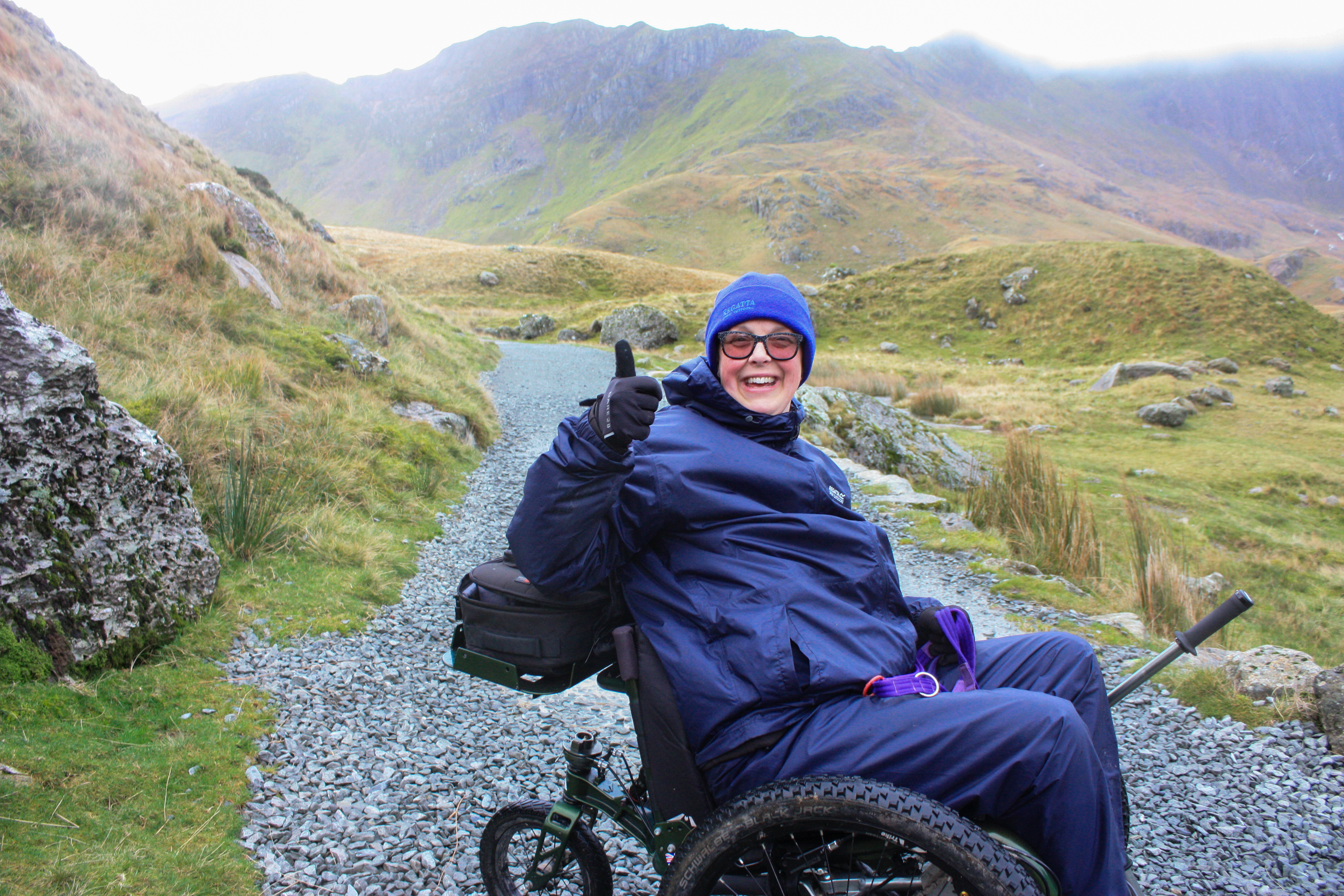
I'll come back to the story behind the photo later but a friend commented on it:
Just how many miles have you walked on this trip to Wales? I admire your stamina indeed I do. Love the mountains. However do you do hills on the trike?
I was thinking about how to answer her question and that prompted this post.
A bit of history
In May 2016, we went on a cruise to the Norwegian Fjords. One of our visits was to a glacier, which had a path up to a viewing area. We decided to give it a go, but I was over 17 stone and not at all fit back then. I had only been using a wheelchair for a couple of years and hadn't done anything more adventurous than going round the supermarket. If we went out for the day, I tried to borrow a scooter from Shopmobility. So the visit, whilst interesting, just emphasised our lack of fitness and need to lose weight.
Not long after that, the BBC had a fitness campaign called Make Your Move. It's a long story but I ended up becoming one of their ambassadors and they put together a page all about my challenge ![]() . The photo I gave them was from the hike up the Norwegian glacier.
. The photo I gave them was from the hike up the Norwegian glacier.
That BBC challenge pretty much transformed my life! I began to get fit and lost 4 or 5 stones in weight but I also realised how important it is to have a strong upper body. There's not a lot I can do about my lower body. The nerves are damaged and anything I try to do to build strength causes more pain than it is worth. In order to have independence and the ability to do the stuff I enjoy doing, I absolutely must keep my upper body in good condition and keep building strength.
Climbing Snowdon
So back to our recent holiday in Wales. We spent half the week in Anglesey and half in Snowdonia. My original plan was to take the railway up Snowdon but I soon discovered some issues with that. The first was that the summit building is currently closed and there are no toilets on the train or anywhere on the mountain. The second, which was even more of a problem, is that we arrived there on 1st November and the trains stop running on 31st October.
Not to be deterred, and inspired by recent stories of other mountain trike users climbing little hills like Kilimanjaro, I started looking into whether we could give Snowdon a go. The difference is that all these intrepid mountaineers have massive teams of helpers that carry them over the tricky bits and basically make sure they don't die on their climb. I don't have that big a team. My team is me, Neil and Liggy.
After doing some research though, I decided that we could attempt the Miner's Track and just go half way. It goes up from the Pen-y-pass car park to a big lake, Llyn Llydaw, before getting very steep and scary. So we decided to do the bottom half. I booked car parking for the motorhome, which was complicated but the wardens there were fantastic, realising they had an opportunity here to fulfil someone's dream, and they coned us off a double length space and didn't even charge us.
The weather on the day was not ideal! It was forecast to rain all day, and I mean all day. 100% chance of rain from about 8:00 a.m. until late afternoon. Even worse was the wind, which was due to be around 90mph by 14:00. We did consider cancelling but eventually decided to go ahead, go early and wear the best waterproofs we could, hence my Michelin Man look in the earlier photo. I had my cross-country ski coat and trousers underneath my waterproofs.
We let the warden at the car park know our plans and that we would be back within 4 hours. He reminded us of the 14:00 wind forecast and warned us about current levels and gusts. I have to admit, I was a little bit scared, as it was already really windy and the gusts took our breath away... but we decided to take it a bit at a time and if it became unsafe at any point, we agreed we would just turn around and come back to base.
The climb
I had done a lot of research, so I knew that the first section was steep and that the gravel was quite loose. We had already planned that this would be a team effort. Neil pushed. I used my levers. Liggy sniffed around a lot but decided that pulling wasn't appropriate behaviour for an assistance dog. By the time we had scaled the first section, we were quite out of breath and already tired.
The next section, whilst still largely uphill, was a little less intense but we were already battling strong gusts of wind and had to keep stopping to avoid being blown over. We would have loved to photograph and video it all but safety was the priority so we actually didn't get many photos. I tried to do the less steep bits under my own steam. It is hard to describe a technique but I try to keep my core muscles tight, to protect my lower back and I try (though it is difficult) to keep my shoulders down and use my arm muscles to push the levers. When I get tired, I either find a point to aim for... the next peak, a stone, a plant... and use all my effort to get there and then rest a bit, or I do a certain number of pushes, either 10 or 20, and then stop and get my breath back.
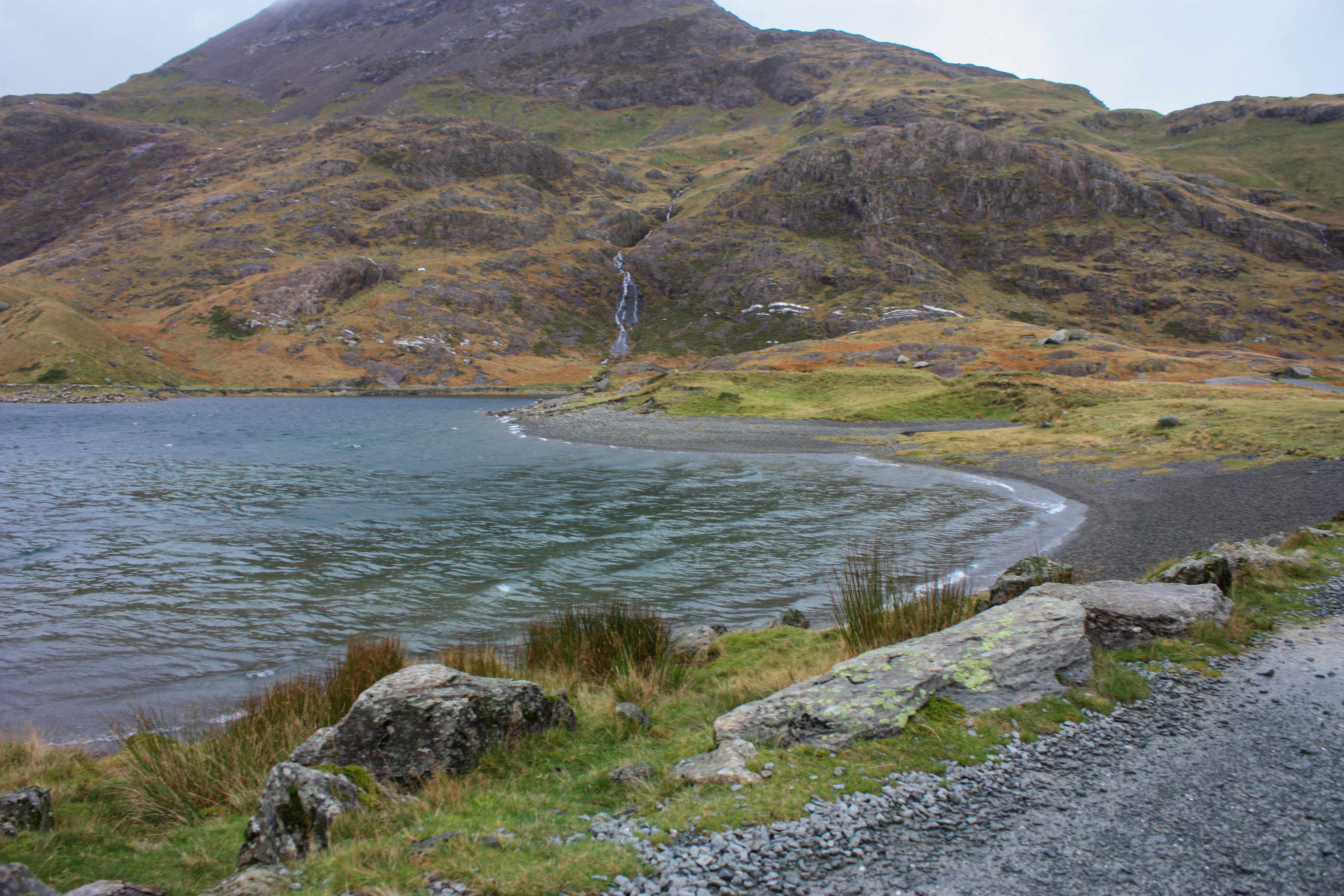
Llyn Llydaw
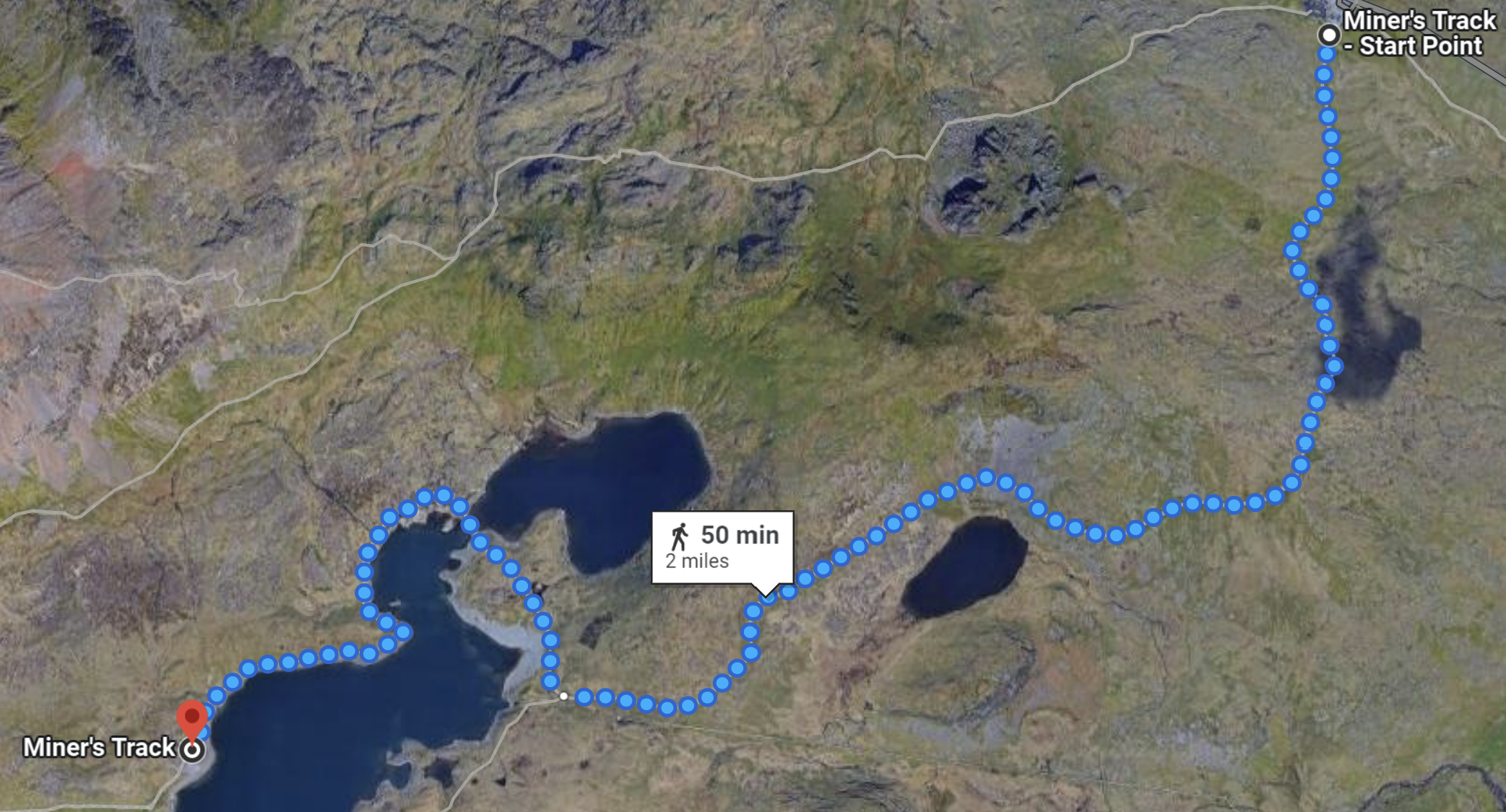
The original plan had been to cross the causeway over Llyn Llydaw, go round the shore and stop at an old ruin for lunch. However, in consultation with various passers-by, and in light of the declining weather conditions, we decided to stop just before the causeway. On the map, you may notice a grey slate beach area. We stopped there, let Liggy have a quick paddle, took some photos and then turned back, conscious of the need to get off the mountain before the rain set in and the wind became even stronger. As it happened, this was a good call. The rain became really heavy just as we got back to the car park.
The descent
Whenever we plan a day out, we get somebody warning us about hills and how impossible it will be to get me up the hills in a wheelchair. Whilst these are well meaning warnings, many people don't realise that actually, in my trike, going down is often more difficult than going up. It was telling that Craig Grimes, the guy from Experience Community, who taught me how to use the trike, warned us about the down rather than the up. I asked him (as he knows my capabilities) whether he thought we'd manage the planned route. His response:
I reckon you’ll be fine, just be mindful that whatever you go up you have to come back down! Oh and make sure you don’t fall out!
I love the trike! The technology behind it is just brilliant! However, coming downhill gets tricky because the steering is all on the back wheel. On the right hand lever, I control the back wheel and the brakes. If I'm coming downhill, and braking, that means I tend to tip forwards slightly, lifting the back wheel off the ground, which means I have no steering at all. To counter this, I try to lean as far back as possible so that my weight keeps the back wheel on the ground. The steeper the hill, the less easy this is to achieve and loose gravel makes it even trickier.
I was actually quite scared about the descent but the wind ended up helping me out a bit. There was a section that could have been really tricky but the wind was strong and in my face at just the right moment. Even without my brakes on, my speed was easily under control. In fact, I had to propel to keep moving at one point. There was also a long slow climb section around another lake. I thought Neil would need to help me but I took it at a gentle pace and managed it completely by myself. He did have to help me on a couple of steep downhill bits when the wind was behind me. He pushes the luggage tray down to keep the back wheel in contact with the floor.
Fitbit
Finally, to go back to my friend's original question: Just how many miles have you walked on this trip to Wales?
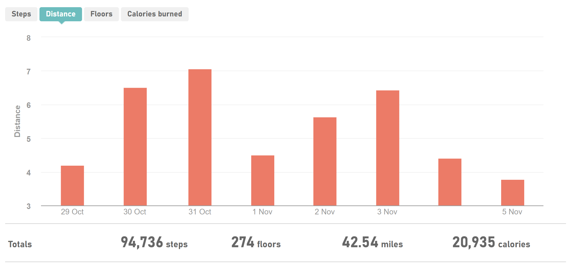
I know exactly how many miles I did because I wear a FitBit which measures my steps (well arm movements that propel me) and thus my mileage. It also measures 'floors'. In theory, this tells you how many flights of stairs you have climbed but for me, it is a good indicator of how many hills I've climbed. So here are a couple of graphs. I've put the data in tables after each screenshot, so screen reader users might find that more useful.
Distance travelled
| Date | Distance | Notes |
|---|---|---|
| 29th October | 4.19 miles | Travel day, long drive to Wales but stopped at Penrhyn Castle and Gardens on way in for a walk. |
| 30th October | 6.51 miles | Beaumaris - visited castle, town, pier. |
| 31st October | 7.07 miles | Holyhead - visited promenade, town, country park and RSPB. |
| 1st November | 4.50 miles | Llandudno - visited pier but then drove around the Great Orme. |
| 2nd November | 5.63 miles | Snowdon - climbed Miner's Track to Llyn Llydaw. |
| 3rd November | 6.44 miles | Stayed local in Betws-y-coed - explored village. |
| 4th November | 4.41 miles | Llanberis Lake Railway and National Slate Museum - train ride and short walks around museum and lakeside. |
| 5th November | 3.79 miles | Travel home - no walks until back home. |
My total distance for the week was 42.54 miles. Now that is measured by my Fitbit converting steps (created by propelling movements) into distance. There are a couple of issues with that, not least that when I'm going downhill, I don't propel but I do cover distance. So most of my downhill distance is not calculated. It is therefore likely that the Snowdon distance should be much more. Also, it keeps counting when I'm doing normal daily stuff. So if I go to the toilet, it's going to calculate that into the distance figure.
Elevation/climb
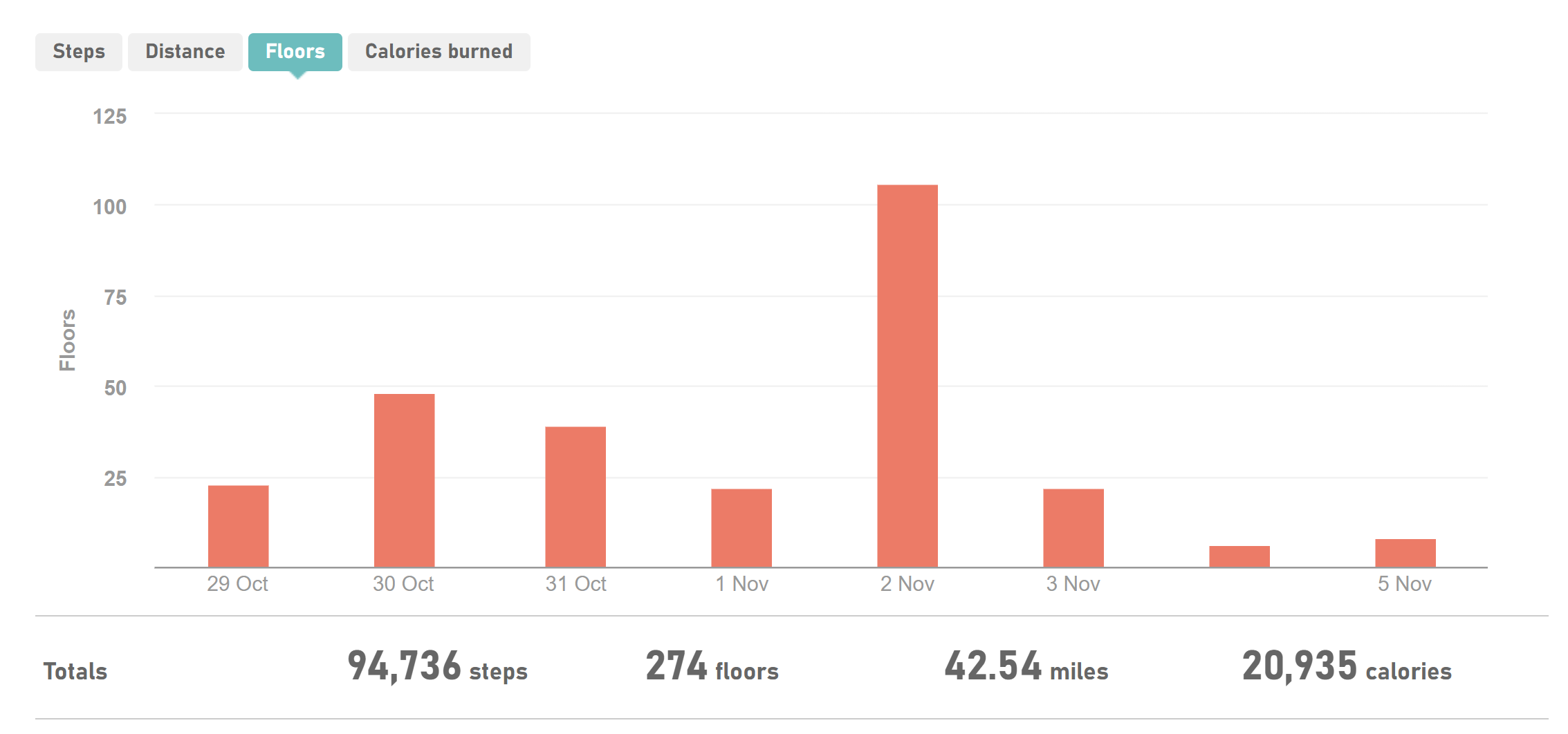
| Date | Floors | Notes |
|---|---|---|
| 29th October | 23 | Travel day, long drive to Wales but stopped at Penrhyn Castle and Gardens on way in for a walk. |
| 30th October | 48 | Beaumaris - visited castle, town, pier. |
| 31st October | 39 | Holyhead - visited promenade, town, country park and RSPB. |
| 1st November | 22 | Llandudno - visited pier but then drove around the Great Orme. |
| 2nd November | 106 | Snowdon - climbed Miner's Track to Llyn Llydaw. |
| 3rd November | 22 | Stayed local in Betws-y-coed - explored village. |
| 4th November | 6 | Llanberis Lake Railway and National Slate Museum - train ride and short walks around museum and lakeside. |
| 5th November | 8 | Travel home - no walks until back home. |
I rarely pay much attention to the floors on my Fitbit, as I live in an area that is largely flat and I use a stairlift at home, which skews the data somewhat. On this holiday though, it does give a relative pattern to the amount of hill walking we did. Obviously, the Snowdon day was massively more than the other days but the first half of the week, we were on a campsite that was quite hilly, so just walking Liggy involved some 'floors'. We also did some walks in hilly places, around castles, coast lines and country parks. The last two days are more like my 'normal' activity levels. This is why we need these hiking holidays so much. Although I walk Liggy two or three times a day, I rarely do any hill work, and it is the hills that really build those arm and shoulder muscles. I'll be honest, I'm still feeling it. My upper arms and shoulders ache quite a bit but that should turn to muscle now and enable me to do more hiking another time.
I hope that answers the question. It ended up being a long post. If you've read to the end, thanks and well done!